

The ice ages in the European Alps: Tannwald research borehole
How did climatic conditions change in the European Alpine region during the Ice Age? How did they control glacier movements and shape flora and fauna over the millennia? LIAG's research boreholes in the alpine overdeepened basin "Tannwald" near the municipality of Winterstettenstadt should provide information about the climatic history of the past 450,000 years approximately in the region. This is part of the ICDP project "DOVE - Drilling Overdeepened Alpine Valleys".
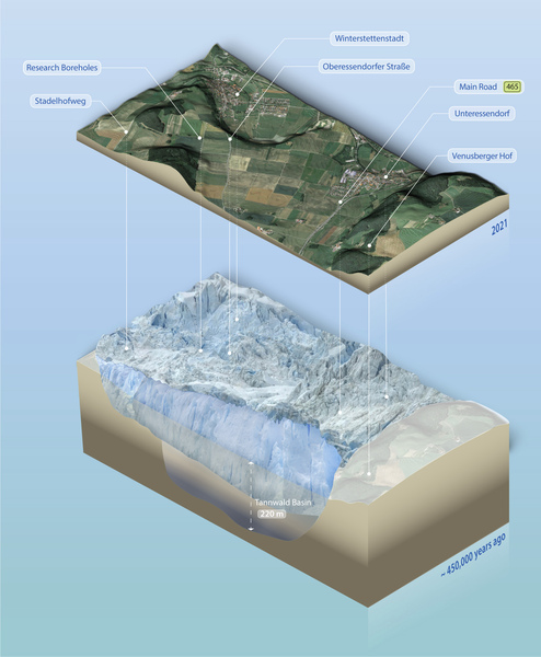
Research Borehole Tannwald Basin provides information on climate and landscape development
The Alpine region is extremely sensitive to environmental and climatic changes, hydrogeological conditions and tectonic processes. Even more intense research on the various geoscientific aspects is therefore required against the background of the societal challenges faced by this region. The over-deepened valleys and basins are particularly important in this context, because inner Alpine areas are frequently densely populated.
With this research well in the Tannwald Basin (Winterstettenstadt), in Baden-Württemberg, we investigate a typical example of many over-deepened valleys and basins in the Alps with three research boreholes (two flush boreholes and one core borehole). The main aim of the project is the methodological development of geophysical aspects, with the aim of improving the physical characterisation of the Quaternary sediments in over-deepened Alpine valleys and basins. This provides information on climatic and environmental changes in the recent past in the area in question, and they can also contain important groundwater potential. Therefore the still unexplained genesis of these valleys needs to be much better understood. The primary objective of the project is the geophysical characterisation of basin morphology and the basin sediments. The complex structure of the basins, as well as the petrophysical contrasts, make it necessary to further develop geophysical exploration techniques.
Kick-off for international project
The research drilling is taking place within the project "DOVE - Drilling Overdeepened Alpine Valleys" of the International Continental Scientific Drilling Programs (ICDP) and initiates the first phase. The overall aim of the project is to reconstruct the spatial and temporal climate evolution during the ice ages over the past 2.6 million years in and around the Alps. This includes a cross-method, geologically oriented processing of up to 16 core drillings around the European Alpine region. More than 20 national and international partner organizations with over 100 scientists are participating in the large-scale project.

Start of research drilling in April
Starting in April 2021, two flush drillings and one core drilling, each with a depth of around 160 meters - arranged as a triangle 28 meters apart - will be carried out within an area of 1500 square meters near Winterstettenstadt. The project will start with the flush drilling, which is expected to take around 10 working days. The installation of the drilling rig will take place from April 6.
During drilling, PVC casing will be inserted into the boreholes so that researchers can take geophysical measurements of the nature of the sedimentary layers in the subsurface using various probes. The international project partners will analyze the samples obtained for their age, pollen concentration or the presence of microorganisms, among other objectives. All the drillings should be completed by the end of July. After about three years, the boreholes will be backfilled and dismantled.
Seismic pre- and post-investigations
To obtain a detailed picture of the subsurface, the researchers will again conduct seismic measurements between the boreholes. With that they contribute to the understanding of the sedimentation processes in detail.
Seismic preliminary explorations enabled safe site selection
As early as 2017, LIAG carried out seismic preliminary explorations. For this purpose, the measuring device developed at the institute sent artificial seismic waves into the ground. The individual sediment layers reflected the beams, which were recorded by geophones. This made it possible to determine the position of the various seismic measuring device sediment layers. In addition, data from boreholes drilled in the 1990s were used to create the 2-D as well as 3-D models of the subsurface. In the project, the researchers used this information to select the best possible locations for the drillings. Due to the extensive preliminary investigations of the LIAG and the LGRB, the geological subsurface is very well recorded. Very experienced geologists in close cooperation with the clients and the drilling company supervise the project.


Informationsgelegenheiten vor Ort

For information on daily drilling progress in the Tannwald Basin, as well as other boreholes throughout the project (such as in Basadingen, Switzerland), please visit the ICDP DOVE project page.
Project Management
Duration
2014 - 2023